Ronch to Val de Udai
Sèn Jan di Fassa, Mazzin · about 40 min by car from Bolzano
The walk
4.3 km out-and-back walk between Sèn Jan di Fassa and Mazzin, up to Paradores - Val de Udai (bivio 580), 275 m of total ascent: about 1 h 45 min of walking. Waymarked CAI hiking trail, between 1519 and 1687 m above sea level. After the walk: lunch at Ciasa dò Parè in Soraga (5.7 km).
Waymarked hiking trail (grade E): paths and dirt roads, good walking shoes are enough.
How to get there
By car
From Bolzano: about 40 min (26 km as the crow flies). Most trailheads have roadside parking or a small car park in the nearest village.
By train and bus
Take a train to Bolzano, then a regional bus or a taxi for the last stretch. Our link plans the whole trip with Google Maps public transport.
Start point
46.44775,11.69152
Coordinates of the first waymark. Paste them into any map app.
Country buses run less often on Sundays and holidays, and some not at all: check the return journey before you set off.
Where to eat and drink
Book tastings ahead, and check opening days: many osterie close one day a week.
A good day here
- 10:00Park near Sèn Jan di Fassa and start the walk.
- 11:45Back at the start after about 1 h 45 min.
- 13:00Lunch at Ciasa dò Parè in Soraga, 5.7 km by car.
More walks near Bolzano

Trentino-South Tyrol · Sèn Jan di Fassa
Rifugio Ciampedìe to Gardecia
5.7 km2 h241 m upOut & back
Osteria 3.8 km
About 35 min by car from Bolzano
Trentino-South Tyrol · Sèn Jan di Fassa
Val de Sen Nicolò to L Pief
5.9 km2 h 45476 m upOut & back
Osteria 6.4 km
About 45 min by car from Bolzano
Trentino-South Tyrol · Campitello di Fassa
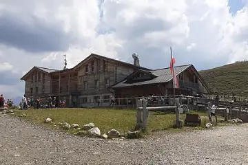
Rifugio Micheluzzi to Rifugio Sassopiatto
5.9 km2 h 45468 m upOut & back
Osteria 11 km
About 40 min by car from Bolzano